



1. Anatomy of a mountain traverse in the high mountains
In mountaineering and high-altitude tourism, the term "traverse" (or ridge traverse) refers to a passage along the length of a mountain range or massif, usually following the main ridge, without descending into the forest or foothills. In contrast to the standard ascent of a peak and subsequent return along the same route, a classic traverse is a linear or circular journey that connects distant geographical points, passing through a series of peaks, saddles, and steep passes.
Characteristics of extreme trekking in Pirin:
- Scale and distance: Long hikes with a total length of 20 to over 100 kilometers depending on the chosen variation.
- Duration: Multi-day autonomous tours requiring strategic planning of overnight stays (between 3 and 8 days).
- Terrain: Highly rugged, composed of rocky scree, moraines, unstable blocks and narrow, exposed edges.
- Positive displacement: Huge vertical load, often exceeding 1500 - 2000 meters of ascent within a day.
- Height zone: Movement mainly in the subalpine and alpine zone above 2500 meters above sea level.
2. The Great Birn Traverse (3-day classic route)
This is the fundamental route for advanced hikers, following the very backbone of the mountain. The terrain changes dramatically – from the raw white marble karst of the Vihren massif to the heavy, dark granite moraines around Lake Tevno. Choosing these hiking in Pirin, you are touching the wildest part of the Balkans.
| Parameter | Route specification |
|---|---|
| Difficulty | ⭐⭐⭐⭐ (High / Technical) |
| Journey Time: | 3 full days |
| Total elevation gain | +/- 2200 meters |
| Recommended season | July – September (in the absence of snow patches) |
Day 1: Banderitsa area → Vihren Hut
A relatively short, introductory day intended for logistical adjustment. Arrival in the area of Bansko and the climb to Vihren hut (1950 m above sea level) allows the body to begin initial acclimatization. Overnight accommodation requires mandatory advance reservations months in advance, as the hut is a main starting point for the highest parts of the mountain.
Day 2: Vihren Hut → Tevno Lake Shelter (6-8 hours)
The heart of the Alpine trek. The route leaves the hut, crosses the Banderishki Circus and heads towards Bashliyska Porta and the Preval Lakes. The trail passes through very rugged terrain. The key point is overcoming Mozgovishka or Vinarska Porta, depending on the weather conditions. Here the markings often become difficult to see, so it is imperative to follow the stone markings (pyramids) and winter markers. The final goal is a shelter Tevno Ezero (2512 m above sea level) – the highest accommodation with permanent staff in the country. The conditions here are spartan (shared bunks), but the location is strategic.
Day 3: Tevno Lake Shelter → Bezbog Hut
The final stage passes by the mighty granite silhouette of Kamenitsa peak and descends to Popovo Lake – the largest and deepest lake in the Pirin Mountains. The descent puts a serious strain on the knees and requires extreme concentration until you reach Bezbog Hut (2240 m above sea level), from where you can use the chairlift to Dobrinishte.
3. The Mega-Traverse: Rila and Pirin (8-day epic expedition)
For mountaineers seeking the ultimate challenge, there is the legendary connection of the two largest high mountain ranges in the Balkans. This trek combines the peak of the peninsula – Musala Peak (2925 m) in Rila, with the emblematic peak of Pirin, Vihren Peak (2914 m).
Logistical challenges along the route
The cleanest mountain trek from an ecological point of view requires a descent from the southern slopes of Rila (after passing through the Macedonia hut) to the Predel saddle. Predel represents the physical border between the two mountains and is crossed by a busy asphalt road. From here begins the brutal and long climb of the Pirin massif towards the Yavorov hut, which tests the endurance of the lower limbs due to the large elevation gain within one trekking day.
4. The "Horse" Phenomenon - A Test for the Psyche
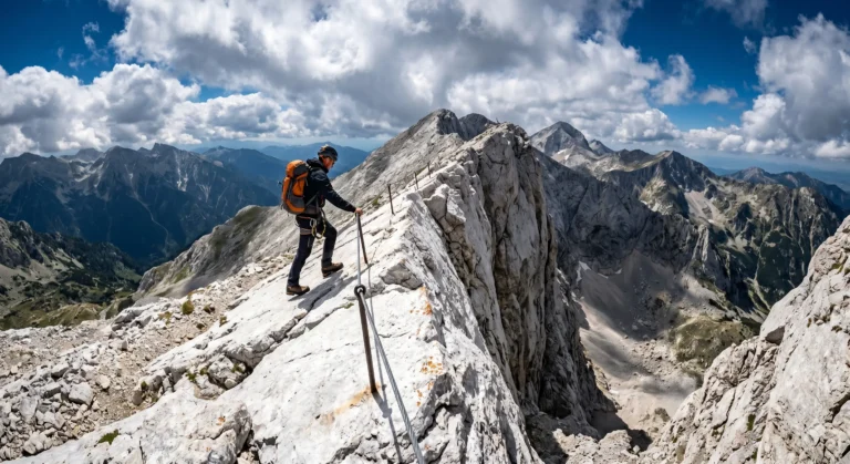
There is hardly a more famous and at the same time more terrifying rocky section in Bulgaria than the karst ridge "Koncheto". This narrow saddle connects the peaks of Banski Suhodol and Kutelo, rising to over 2800 meters in height. In places the width of the ridge is only 50-70 centimeters, and on both sides dizzying, almost vertical precipices descend to the circuses of Kazana and Bayuvi Dupki.
Basic safety rules when crossing:
- Compulsory insurance: The edge is secured with a steel rope. Use it as a handrail at all times. For people who feel insecure, it is highly recommended to use a climbing seat and a via ferrata set (two straps with carabiners with an automatic coupling).
- Absolutely prohibited in bad weather: The metal rope acts as a giant lightning rod during a storm. At the slightest sign of cumulonimbus clouds or static electricity in the air, the crossing must be canceled!
- Vertigo control: If you have a severe fear of heights (acrophobia), this route can be mentally paralyzing. Assess your options soberly before setting foot on the cliff.
5. Technique for navigating the “Stone Rivers”
When you are planning serious hiking in Pirin, you should be prepared that you will rarely step on soft forest soil or grassy lawns. The mountain is covered with kilometers of moraines and screes, called simply "stones" by local guides.
Proper technique requires transferring your body weight only after you have made sure that the stone under your feet is completely stable and will not roll over. Always step in the center of large boulders. Shoes with soft soles are dangerous here - the sole must have serious torsional stiffness (index B/C or C) and a deep grip, accompanied by a high rubber rim, protecting the ankle from the sharp edges of the granite.
6. List of mandatory equipment for the high zone
Compromises with equipment in the alpine zone can cost you your health or your life. Your inventory should include the following critical items:
- Three-layer clothing: Thermal underwear (merino wool or synthetics), an insulating mid layer (technical fleece) and an outer jacket with a three-layer waterproof membrane (Hard shell) that can withstand at least 20,000 mm of water column.
- Navigation set: A charged GPS receiver with a topographic map of Pirin (e.g. BGMountains), a spare compass and a physical paper map. The phone is not a reliable tool in low temperatures.
- Front reflector (headlamp): With a power of over 300 lumens and an additional set of batteries or an external battery (Power bank).
- Hydration: Water containers with a total capacity of at least 2.5 – 3 liters. In the karst part of Pirin (between Yavorov hut and Vihren) there is not a single source of drinking water!
7. Objective hazards and risk management
Dense fog and disorientation
The Pirin ridges are known for their fast-falling fogs, which reduce visibility to less than 2-3 meters in a matter of minutes. In such a situation, staying on the ridge requires strict adherence to the winter stake markings. Leaving the trail can lead you to the sheer gullies on the north faces, where a slip is fatal.
Summer thunderstorms
The specifics of the relief lead to intense convective processes during summer afternoons. The golden rule for advanced mountaineers is: departure at 04:30 – 05:00 in the morning, so that the most exposed and high areas (such as Koncheto Ridge or Vihren) should be crossed before noon, when the risk of lightning is lowest.
Important emergency numbers:
Mountain Rescue Service (MSS): 112 or (+359) 2 963 2000
Before undertaking hikes in Pirin, always install the MES application and take out mountain insurance with a high limit for rescue operations.