It is 13° in Bansko now.
cloudy
English (UK)
English (UK)
Български
Русский
Login
Business in Bansko
Transportation and cars
Health and beauty
Hotels and accommodation
Properties, renovations and home
Restaurants and dining
Services and business
Shopping
Entertainment
Bars and nightlife
All businesses
Business Center Bansko
Accommodation
Events
Guides
The tourist
To the seller
To the buyer
To the owner
For new residents
Bansko on four paws
Useful
Properties in Bansko
Travel guide
Ideas and tips
News
About Bansko
Multimedia
Photo
Video
It is 13° in Bansko now.
cloudy
Login
TOURISM AND NATURE
March 27, 2026
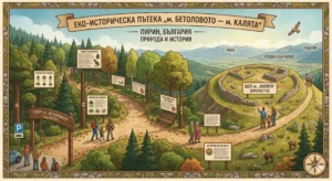
Eco-historical trail "Betolovoto" - "Kalyata" - A journey through time and nature
March 26, 2026
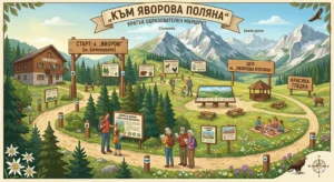
Educational trail "Yavorova Polyana" - Revealing the secrets of Pirin
March 26, 2026
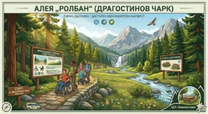
Rollban Alley (Dragostinov Chark) – The accessible embrace of Pirin
March 26, 2026
Difference between a route and a trail in Pirin: A guide from Bansko
March 26, 2026
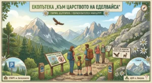
Eco-trail "To the Kingdom of Edelweiss" - On the way to the symbol of Pirin
March 26, 2026
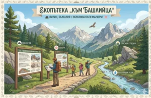
Eco-trail "To Bashliytsa" - A journey through the geological secrets of Pirin
March 26, 2026
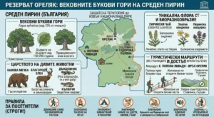
Orelyak Reserve: The ancient beech forests of Middle Pirin
March 26, 2026
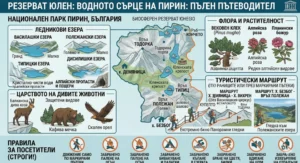
Yulen Reserve: The Glacial Lakes and the Watery Heart of Pirin
March 26, 2026
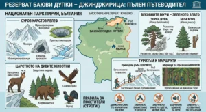
Bayuvi Dupki Reserve – Dzhindzhiritsa: Complete Guide
March 26, 2026
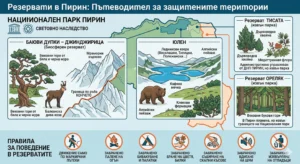
Pirin Reserves: Guardians of Wildlife
March 26, 2026
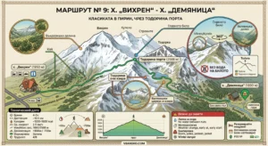
Route No. 9: From Vihren Hut to Demyanitsa Hut – High Mountain Adventure via the Main Ridge
March 26, 2026
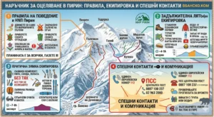
Pirin Mountain Survival Guide: Rules, Equipment and Emergency Contacts
Previous
Page
1
Page
2
Page
3
Page
4
…
Page
16
Next
We've detected you might be speaking a different language. Do you want to change to:
Български
Български
English (UK)
Русский
Change Language
Close and do not switch language
We've detected you might be speaking a different language. Do you want to change to:
Български
Български
English (UK)
Русский
Change Language
Login
Registration
Remember me
Forgot Password?
Login
I agree to the terms and conditions and privacy policy of vBansko.com
Registration
Lost your password? Please enter your username or email address. You will receive a link to create a new password via email.
Reset password
body::-webkit-scrollbar { width: 7px; } body::-webkit-scrollbar-track { border-radius: 10px; background: #f0f0f0; } body::-webkit-scrollbar-thumb { border-radius: 50px; background: #dfdbdb }
Business in Bansko
Transportation and cars
Health and beauty
Hotels and accommodation
Properties, renovations and home
Restaurants and dining
Services and business
Shopping
Entertainment
Bars and nightlife
All businesses
Business Center Bansko
Accommodation
Events
Guides
The tourist
To the seller
To the buyer
To the owner
For new residents
Bansko on four paws
Useful
Properties in Bansko
Travel guide
Ideas and tips
News
About Bansko
Multimedia
Photo
Video
Back
Login
Remember Me
Login
Lost your password?
|
Register
EN
BG
RU


 cloudy cloudy cloudy