Do you dream of a real mountaineering challenge that will test your will and reward you with unearthly views? The international E-4 trek (Route No. 1) through Pirin is exactly that. Within a few days, you will pass through the harshest karst edges, admire crystal-clear glacial lakes and feel the magic of ancient forests. This is the most impressive high-mountain route in Bulgaria, connecting the Predel Pass with Popovi Livadi. Are you ready for adrenaline?
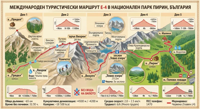
Official name: Predel hut - Yavorov hut - Vihren hut - Tevno Ezero shelter - Pirin hut - Popovi Livadi village (part of international route E-4)
📊 Technical data (Telemetry):
- ⏱️ Time without breaks: 31:30.
- ☕ Time with breaks: About 4 to 5 days (depending on overnight stays)
- 📏 Distance: ~ 65 km (approximate for the entire hike)
- 🔥 Calories: ~ 18,500 kcal
- 🏃 Average speed: 2.0 – 2.5 km/h (due to the alpine terrain)
- ⬇️ Lowest point: 1040 m above sea level (pass Limit)
- ⬆️ Highest point: 2914 m above sea level (Vihren Peak)
- ▲ Elevation: +4500 m / -4200 m (cumulative)
- ⛰️ Difficulty: 6/6 (Very difficult, requires serious experience)
- ✨ The Bulgarian pearl: The Pirin stage is considered the most extreme and breathtaking part of the entire Trans-European Road (Pyrenees – Alps – Peloponnese).
- ✨ On the edge of the abyss: The trail runs along the iconic karst edge The horse, offering 360-degree panoramas.
- ✨ Lake magic: During the hike, you will enjoy views of over 30 mountain lakes in the deep cirques.
🚗 How to get there? (Logistics)
By car: The starting point is the Predel pass (coordinates: 41.8845° N, 23.3255° E). The road surface in the direction of Simitli – Bansko is excellent asphalt. There are convenient and free parking spaces in the area of the Predel hut. Since the route is linear, you will need transportation to return from the Popovi Livadi area (taxi or bus to Gotse Delchev and from there to the starting point).
On foot: The hike starts directly from the Predel hut. You enter dense coniferous forests, and you must strictly follow the the red tape marking, which will be your guide until the very end.
🥾 Description of the route
Due to the extreme workload, the classic schedule is spread over 4 or 5 days:
- Day 1: Predel Hut – Yavorov Hut: A smooth start through forests and meadows. The climb takes about 6 hours, reaching the hut (1750 m above sea level) for the first night.
- Day 2: Yavorov hut – Vihren hut (via Koncheto): The most extreme and longest day (9-10 hours). You move along the rocky karst ridge, pass through the "Koncheto" shelter, the very edge and climb the Vihren peak. A steep descent follows.
- Day 3: Vihren hut – Tevno Lake shelter: The most panoramic part (6-6.5 hours). The hike winds through high mountain saddles and lake cirques to the iconic shelter.
- Day 4 and 5: h. "Tevno lake" - h. "Pirin" - "Popovi Livadi" town: Descent to Pirin hut (4 hours) and the final, gentler stage to Middle Pirin (7-10 hours), where the rocks give way to forests.
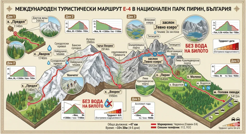
This detailed isometric infographic map visualizes the complete 5-day International Hiking Route E-4 through the heart of the Pirin Mountains, Bulgaria. Tracing the hike from Predel Hut to Popovi Livadi, it combines topographic relief with technical data. The image highlights iconic landmarks such as the Koncheto Ridge, Vihren Peak (2914 m) and Tevno Lake Shelter (2512 m). For each segment (Day 1 to Day 5), graphs show distance (~km), approximate time (h) and elevation changes (e.g. +1360 m / -760 m). A large safety warning in red text highlights the critical information: „NO WATER ON THE MOUNTAIN“. The map defines the difficulty of the hike as extreme (6/6).
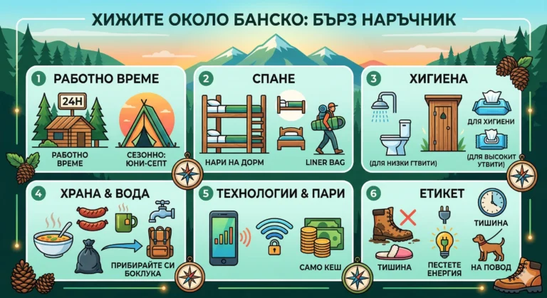
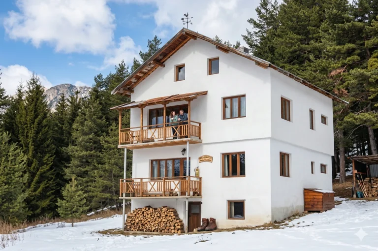
🏠 Basic information about the sites (Huts and shelters)
Conditions along the long route vary, but the main bases (Yavorov hut, Vihren hut,. Tevno Lake, Pirin hut) offer shelter and hot food.
🕒 Working hours: The huts are open year-round; the Tevno Lake shelter may be unstaffed in the winter.
📅 Season: The best time to cross is July - September.
🛏️ Beds: A total of over 300 places, distributed across the stages.
💸 Price: Access to the park is free; overnight stays are between 25 and 40 BGN.
🐕 Dogs: Not recommended due to the highly exposed rocky terrain.
📞 Telephone number: 1470 (Mountain Rescue Service).
⚠️ Important to know
- Lack of water: There is no water source on Day 2 (from Yavorov hut to Vihren hut). Be sure to bring at least 3 liters of water per person.
- Meteorology: Summer afternoon storms on the exposed rim are deadly. Leave no later than 6:00 AM.
- Scope: Along the karst edge and in some cirques, the mobile signal is completely lost.
❓ Frequently Asked Questions (FAQ)
Is the route suitable for children?
Definitely not for complete crossing. The stage through Koncheto requires excellent coordination and no fear of heights. It can only be crossed by older teenagers with serious experience.
Is there somewhere I can charge my phone?
There is electricity in the Yavorov and Vihren huts, but the sockets are limited. The Tevno Lake shelter is on solar panels and charging is difficult. Bring a strong external battery (Powerbank).
Can I do the route in sneakers?
Not recommended. The terrain is extremely rocky. High hiking boots that cover the ankle are a must.