Do you dream of an epic adventure that will test your will and take you through the most beautiful and rugged corners of Bulgaria? Route No. 1, better known as the Pirin section of the international trans-European route E-4 (Pyrenees – Alps – Rila – Pirin – Peloponnese), is exactly that! With a length of 47 kilometers within the National Park, this mega-pass crosses the entire mountain from the Predel Pass to Popovi Livadi. Ahead of you are sheer marble ledges, crystal alpine lakes and age-old mystical forests. Here is your complete guide to survival and enjoyment.
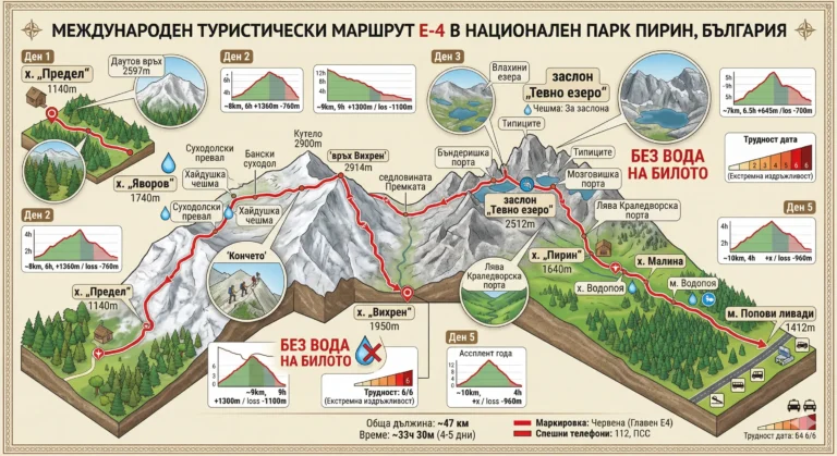
1. ROUTE No. 1 – Predel hut – Yavorov hut – Vihren hut – Tevno Ezero shelter – Pirin hut – Popovi Livadi village
📊 Technical data (Telemetry)
- ⏱️ Duration: About 33 hours and 30 minutes of pure walking time (split into 4 or 5 days)
- 📏 Distance: 47 km (on the territory of Pirin National Park)
- 🔥 Calories: ~12,000 – 15,000 kcal (total for the entire hike)
- 🚶 Avg. speed: Highly variable (from 1 km/h on the marble ridge to 3 km/h in the forests to the south)
- ⛰️ Min/Max height: 1140 m (m. Predel) / ~2860 m (Premkata saddle / The horse)
- 📈 Elevation: Colossal (daily brutal climbs and descents)
- 🔴 Marking: Red (main ridge marking)
- ⚠️ Difficulty: 6/6 (Extreme endurance and technically difficult terrain in Northern Pirin)
💡 Interesting information
- Route E-4 starts in Spain, passes through the Alps and the Carpathians, enters Bulgaria through Vitosha, Verila, Rila, Pirin and Slavyanka, and ends all the way on the Peloponnese peninsula in Greece.
- The stage from Yavorov hut to Vihren hut is considered one of the most difficult, but also the most beautiful hiking routes on the entire Balkan Peninsula.
- By following this route, you will literally see the three faces of Pirin – the alpine marble North, the granite lake Middle Part and the forested, mild South.
🚗 How to get there? (Logistics)
Transportation organization is key, as the hike begins and ends in completely different places.
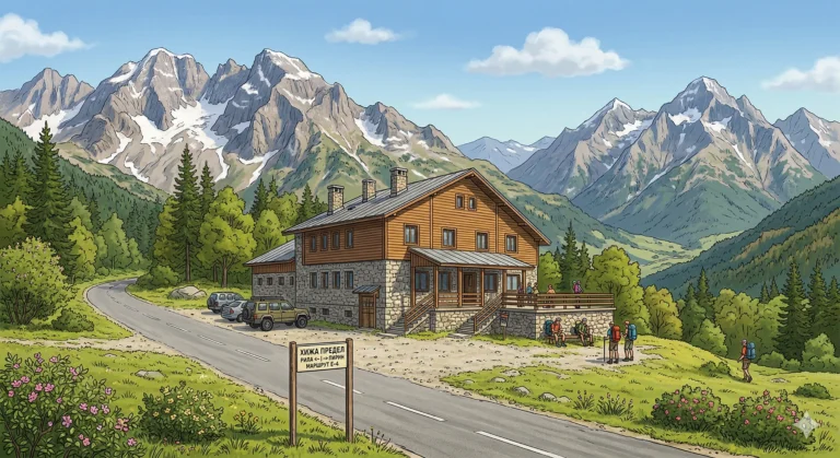
Start (Limit): The Predel Pass is very easy to reach. The main road Simitli - Bansko, where dozens of buses stop daily. You can leave your car there or take a taxi from Bansko/Razlog.
Final (Popovi livadi): The pass above the town of Gotse Delchev is also on a main road. From there you can take a bus or taxi to Gotse Delchev (15 km), from where you can make a connection to Sofia, Blagoevgrad or Bansko.
🥾 Route description (By days)
Day 1: From Predel Pass to Yavorov Hut (⏱️ 6 hours)
The hike starts smoothly from Predela (1140 m), passing through the Tamnite Polyani area. A long and exhausting climb through centuries-old forests to Dautov Vrah awaits you. Once you reach the ridge, there is a panoramic descent to the best hut in Pirin – „Yavorov“ (1740 m). This day is a test of your physical fitness.
Day 2: From Yavorov Hut to Vihren Hut (⏱️ 9 hours)
The king of stages! Start at sunrise. You will have a brutal climb through the Suhodol Pass to the Main Marble Ridge. You will pass over the karst edge of Koncheto (secured with a metal rope), past the peaks of Banski Suhodol, Kutelo and the top of Vihren. The terrain is completely rocky, airy and waterless. The finish is a steep descent to the Vihren hut.
Day 3: From Vihren hut to Tevno Lake shelter (⏱️ 6 hours and 30 minutes)
You leave the marble and enter the granite section. The route passes by the Vlach Lakes, climbs to Banderishka Porta, then follows an endless but stunningly beautiful “horror train” (ascent and descent) through the peaks of Tipitsi. After overcoming Mozgovishka Porta, you descend to the iconic shelter „Tevno Ezero“ for an overnight stay in the heart of the mountain.
Day 4: From Tevno Lake shelter to Pirin hut (⏱️ 4 hours)
Recovery day. From Tevno Lake The route heads south. You pass through the Left or Right Kraledvorska Gate (depending on the winter/summer option) and begin a long, picturesque descent. The alpine landscapes gradually give way to green pastures and forests until you reach the cozy Pirin Hut (1640 m).
Day 5: From Pirin Hut to Popovi Livadi (⏱️ 8 hours)
The final chord. This stage is very long in terms of kilometers, but technically the easiest. It goes mainly through the centuries-old forests of South Pirin, past the Malina hut and the Vodopoya area (under Orelyak peak). After a few hours of forest therapy, the red markings will lead you to the asphalt of Popovi Livadi.
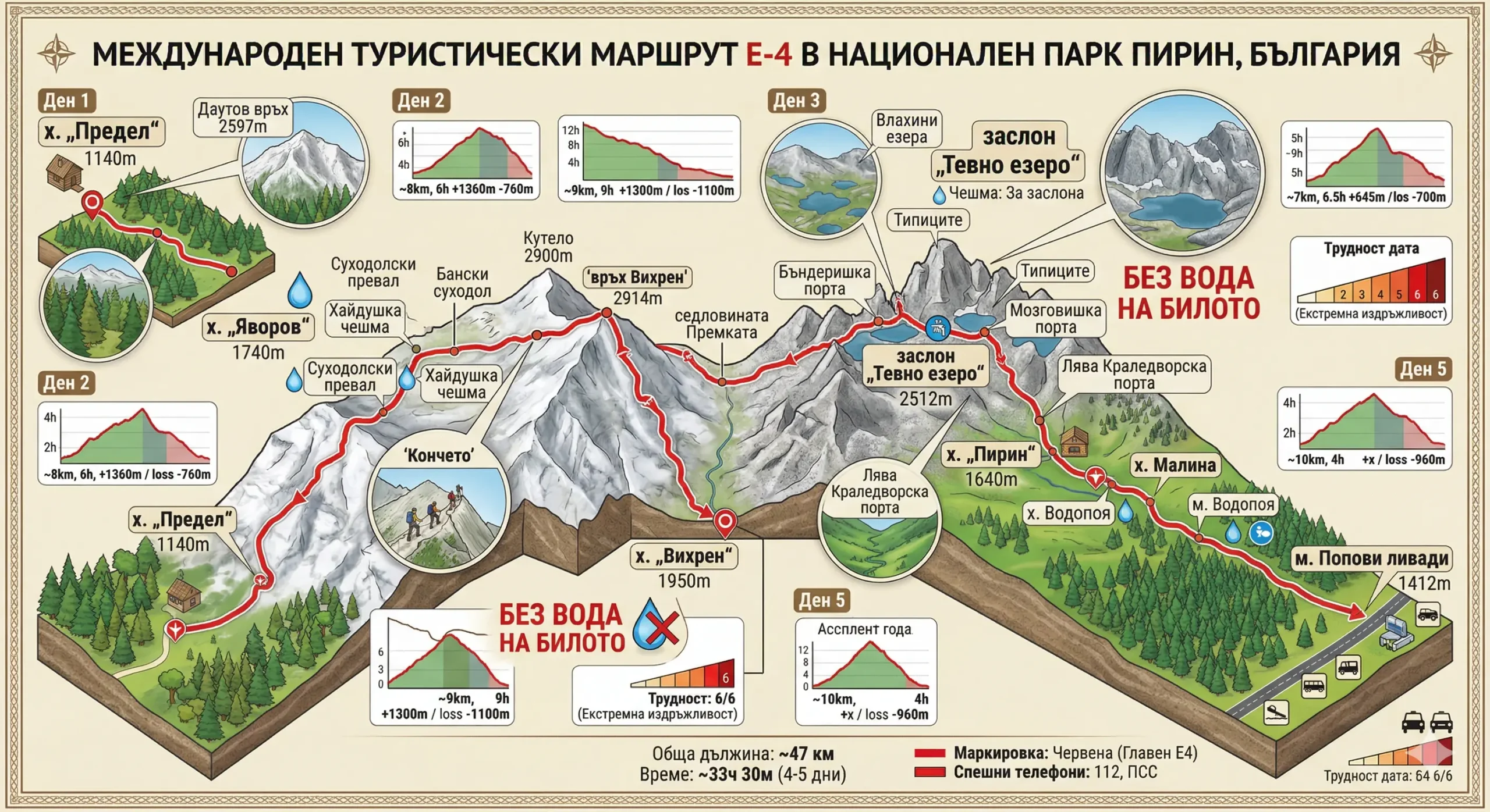
This detailed isometric infographic map visualizes the complete 5-day International Hiking Route E-4 through the heart of the Pirin Mountains, Bulgaria. Tracing the hike from Predel Hut to Popovi Livadi, it combines topographic relief with technical data. The image highlights iconic landmarks such as the Koncheto Ridge, Vihren Peak (2914 m) and Tevno Lake Shelter (2512 m). For each segment (Day 1 to Day 5), graphs show distance (~km), approximate time (h) and elevation changes (e.g. +1360 m / -760 m). A large safety warning in red text highlights the critical information: „NO WATER ON THE MOUNTAIN“. The map defines the difficulty of the hike as extreme (6/6).
🛖 Basic information about the sites (Huts)
To survive on this route, you need to sleep warm and eat nutritious food.
- 📌 Tip: Reserve your places at the Yavorov hut, the Vihren hut and especially the Tevno Ezero shelter at least 2 months in advance!
- ☀️ Season: This transition is made only from mid-July to mid-September. The rest of the time there is snow and crossing the Koncheto is deadly dangerous without alpine equipment.
- 🎒 Equipment: Sturdy shoes, poles, windbreaker, raincoat, headlamp, first aid kit and sunscreen are mandatory. Your backpack should not weigh more than 10-12 kg.
⚠️ Important to know
The water problem: During Day 2 (from Yavorov to Vihren) and most of Day 3 along the ridge not a drop of water. You should bring a minimum of 3 liters per person for the day!
Bad weather: The main ridge (especially Koncheto and Tipitsi) is extremely vulnerable to thunderstorms. If the forecast is bad, do not climb the ridge! Plan a buffer day for waiting in the huts.
❓ Frequently Asked Questions (FAQ)
Can I travel the route with a tent?
Official bivouacing in Pirin National Park is only permitted in specific places (usually near the huts). Lighting fires along the route is absolutely prohibited.
Do I need a helmet and seat for the Horse?
For experienced tourists in the summer in dry weather, the metal rope is sufficient. However, if you are afraid of heights or the weather is wet, a safety harness (via ferrata kit) is highly recommended.
Can I complete the route in fewer days?
Ultramarathoners complete it in under 15 hours, but for a normal tourist, merging Day 1 and Day 2 or Day 2 and Day 3 poses a huge risk of complete exhaustion. 5 days is the optimal balance between workload and pleasure.