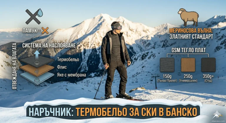
Most tourists reach the majestic Popovo Lake via the popular trail from the Bezbog hut. However, if you are looking for silence, wild forests and an alternative approach, Route No. 16 is your hidden trump card. Starting from the historic site of Harami Bunar, this brown-marked trail winds through the secluded valleys of the Retijë River to take you to the largest lake in the Pirin Mountains, far from the noise of the crowds.
16. ROUTE No. 16 — Harami Bunar village – Popovo Lake
📊 Technical data (Telemetry)
- ⏱️ Duration: About 3 hours (one way, without long breaks)
- 📏 Distance: About 7 – 8 km
- 🔥 Calories: ~800 – 1000 kcal
- 🚶 Avg. speed: ~2.5 km/h (moderate forest and rocky terrain)
- ⛰️ Min/Max height: ~1600 m (Harami well) / 2234 m (Popovo lake)
- 📈 Elevation: About +650 meters of ascent
- 🟤 Marking: Brown
- ⚠️ Difficulty: 3/6 (Medium)
💡 Interesting information
- The area Harami well lies on the old military road "Goren Dervent", built at the beginning of the 20th century, which connected Dobrinishte with Gotse Delchev across the mountain.
- The route crosses the lush Retige River, whose valley hides some of the wildest and most intact forest massifs in Northern Pirin.
- Popovo Lake is not only the largest (over 120 acres), but also the deepest in the mountain (29.5 m), known for its characteristic islet, called "Kalimyavka".
🚗 How to get there? (Logistics)
Reaching the starting point requires prior preparation. The terrain Harami well is located on the black forest road (truck road), which separates high above the villages of Breznitsa and Kremen.
The easiest way to get to the start is by off-road vehicle (4×4) from the road to Gotse Delchev Hut or the village of Obidim. If you are in a standard car, you will have to leave it significantly lower and add at least another 1-2 hours of hiking on dirt roads before reaching the official start of the route.
🥾 Description of the route
1. From Harami well through the forest
The hike starts from the truck road at Harami Bunar, following the brown markings. At the beginning you move through the Lenishki Rid area. The trail is mainly forest, gradually gaining height among beautiful coniferous massifs, passing through the Dalgata Polena and Chalo areas.
2. Retije River and Izvorite area
After about an hour and a half of walking, the trail reaches the key area of Izvorite and crosses the Retije River. Here the yellow marking for the Kremen Lakes and Mount Dzhano (Route No. 18) separates. The area is extremely picturesque and rich in water jumps - an ideal place for rest and refreshment.
3. Climbing the rock ledge
Following the brown markings up towards the cirque, the forest belt begins to give way to the slopes. You will have to overcome a steep rocky threshold (moraines). This section requires more physical effort and attention when walking.
4. Final at Popovo Lake
Overcoming the rocky threshold, the vast blue expanse of Popovoto Lake (2234 m above sea level) opens up before you. Here the brown marking ends, merging with the main tourist trails to the Tevno Lake shelter and the Bezbog hut.
💧 Basic information about the site (Popovo Lake)
There is no tourist infrastructure or hut at the lake itself, so you should be prepared with food and equipment for returning or continuing.
- 📌 Tip: The water in the lake is ice cold even in August. Swimming in it (as in all Pirin lakes) is strictly prohibited!
- ☀️ Season: Recommended from July to September.
- 🛏️ Nearby accommodation: The closest point for overnight stay is the Bezbog hut (about 1 hour and 20 minutes walk along the yellow/green markings).
- 📱 Scope: Around the lake itself, the range is variable, but there is usually a weak signal from the saddle.
⚠️ Important to know
This route is used significantly less frequently than the classic Bezbog – Popovo Lake trail. The brown marking It can be erased or difficult to track in some places in the forest, so using a GPS app (with a pre-downloaded track) is highly recommended.
There is plenty of water when crossing the Retijë River, but in the initial stage, stock up on at least 1 liter.
❓ Frequently Asked Questions (FAQ)
Is the trail suitable for mountain biking?
You can reach Harami Bunar on the dirt road by MTB, but the hiking trail itself up to the lake becomes too steep, narrow, and rocky to ride.
Is it safe from wild animals?
The Retige Valley is wild and rarely visited. Encounters with wild boars, roe deer, and sometimes bears are possible. Move in a group and speak normally to alert animals to your presence.