


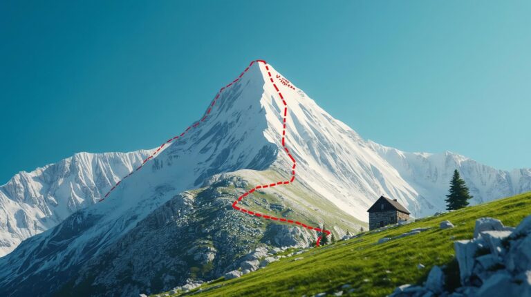
Climbing Vihren Peak (2914 m) – this is not just another hike on the mountaineer’s list. This is an encounter with the „roof“ of Pirin, a test of will and a delight for the senses among the dazzling white marble. This guidebook examines in detail the so-called „King’s Path“ (the route through the Kabata area) – the most popular and accessible way to reach the summit, avoiding the extreme ranges on the northern slope.
The route combines a serious physical challenge with the impressive panoramas of the Marble Mountains. It is suitable for tourists with good physical fitness and experience in all-day hikes, and the views from above encompass almost all of Bulgaria.
📊 Technical data (Outbound and return)
| ⏱️ Time without breaks: | 04:30 a.m. |
| ☕ Time with breaks: | 06:00 – 07:00 a.m. |
| 📏 Distance: | ~7.8 km (two-way) |
| 🔥 Calories: | ~1450 kcal |
| E Average speed: | 1.8 km/h |
| ⬇️ Lowest point: | 1950 m (Vihren Hut) |
| ⬆️ Highest point: | 2914 m (Vihren Peak) |
| ▲ Level difference: | +964 m / -964 m |
| ⚠️ Difficulty: | 4/6 (Physically demanding) |
💡 Interesting facts about the Marble Giant
- ✅ Training ground: Historically, the southern slope was used for training Bulgarian climbers before expeditions to the Himalayas due to the specific slope and thin air.
- ✅ Botanical Paradise: This is the home of the Pirin poppy and Edelweiss, which survive directly on the harsh marble rocks.
- ✅ Anorexia: The peak is karst (limestone), which means that water is absorbed instantly. This makes the area one of the driest in the high mountain.
🚗 How to get there? (Logistics and Parking 2026)
Logistics is the first challenge before the climbing Vihren peak. Since the start is from the hut of the same name, you must comply with the strict regulations of Pirin National Park and the Municipality. Bansko,.
During the summer season (usually from early July to mid-September), the road from The Shiligarnika to Vihren hut is closed to private cars in the time zone 09:00 – 16:00.
- By car: The parking lot in front of Vihren hut is remote and has limited capacity (about 30-40 cars). To find a spot, you need to be there no later than 07:30 in the morning. The road is asphalted, but narrow.
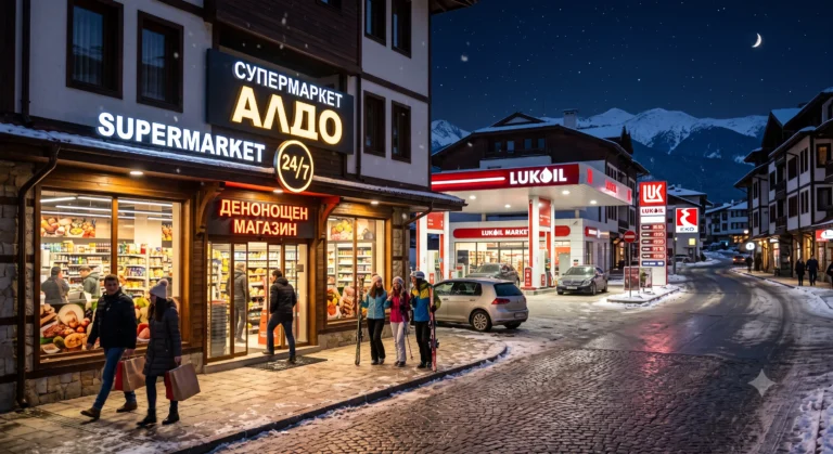
- City transport: We recommend leaving your car in Bansko (at the lift parking lot) and using the regular minibuses that depart from the bus station and the starting station of the gondola lift. The price is affordable and saves you nerves.
- On foot (Start): The starting point is the large stone fountain in front of the hut. This is also the last place with drinking water!
🥾 Detailed description of the route
The route is marked with red tape marking and can be conditionally divided into three key stages.
Stage 1: Vihren Hut – Big Fork (30 min)
You start on the path that goes uphill against the current of the river, but quickly turns to the right along the slope. At first you gain altitude smoothly among squats and grassy meadows. This is the warm-up.
After about 30 minutes, you reach a key junction, indicated by signs and a marking on a large stone:
- Right: The trail leads to "Kazanite" and Yavorov hut (extreme route with chains).
- Left (Your way): Direction "Vrih Vihren" through "Kabata". Turn left!
Stage 2: Branch – Kabata Area (1:30 – 2:00)
Once you take the left path, the serious climb begins. The path enters one of the most beautiful ravines, as the grass gradually gives way to stones. The slope is constant. You will pass through a series of serpentines that will lead you to the area „"The Coat" (The Saddle).
„"Kabata" is a wide saddle between the peaks of Vihren (right) and Hvoynati (left). Here the slope decreases, and a view of the Vlahinskie Lakes opens up in front of you. This is the perfect place for a 15-minute break, a snack on an energy bar, and preparation for the final attack.
Stage 3: Attack of the summit pyramid (45 min – 1:00 h)
From Kabata begins the actual climb to the summit pyramid on the southern slope. The path is clearly visible, winding in a zig-zag among the marble blocks. There are no technical difficulties here, no precipices or chains, but breathing becomes more rapid due to the height and slope.
The marble underfoot can be slippery, even in dry weather, as it has been "polished" by thousands of tourists. Tread carefully!
🗻 At the top: 2914 meters above everything
When you reach the top, fatigue disappears instantly. On clear days, one of the most extensive panoramas in the Balkans opens up:
- To the north: The fearsome marble cliff "The Horse" and Mount Kutelo.
- To the east: The deep cirques of the Banderishki Lakes and Todorka Peak.
- In the distance: Rila (with Musala), the Rhodope Mountains, and with exceptional visibility – the Olympus and Falakro mountains in Greece.
ℹ️ Useful information for tourists
💡 Equipment
- High shoes (required!)
- Windbreaker (it's always windy up there)
- Sunglasses (marble is blinding)
- Poles (help a lot when descending)
⚠️ Safety
- Water: Minimum 2 liters/person
- Departure: No later than 08:00.
- Storms: In case of thunderstorms – get off immediately!
- Insurance: Recommended
❓ Frequently Asked Questions (FAQ)
1. Which route should I choose – via Kabata or via Kazanite?
If you are not a professional or have a fear of heights, the climb to Vihren Peak via Kabata (the southern route) is your choice. It is purely pedestrian. The northern route (via The Kazanites) requires climbing rocks, holding onto metal chains, and crossing over chasms.
2. Is the route suitable for children?
For children over 10–12 years old with good motor skills – yes. For younger children, the serious elevation gain (almost 1000 meters) and the complete lack of shade can be too exhausting and dangerous.
3. Can I bring my dog?
Yes, but with one thing in mind. The sharp marble stones act like razors to the paws of unaccustomed dogs. Bring water for them too, as there are no streams up there.
4. Is there mobile coverage?
In the area of Vihren hut, the coverage is stable. As you gain altitude, the signal is variable – in some folds of the relief it is lost, but at the very top and in the high open parts you usually have 4G.
🗺️ Nearby routes
If you are staying in Bansko for a longer period of time, here are a few more ideas:
- Lake Okoto: Only 20 minutes from the hut – perfect for relaxing after the summit.
- The horse: For extreme tourists – continuation of the route from the top to the north (only with equipment!).
- Sinanitsa Hut: One of the most beautiful, but long hikes in Pirin.
Are you ready for an adventure?
Pirin awaits you! Don't forget to check the forecast for Bansko was liberated before leaving.