


Are you looking for a spectacular hike that will take you off the beaten path and take you across the roof of Pirin? Route No. 20 is a classic high-altitude traverse. It starts with a climb to the fourth highest peak in the mountain – Polezhan (2851 m), then descends into the harsh, wild and insanely beautiful Gazeya Circus. Passing by the highest lake in Pirin, the trail will take you to the cool Demyanitsa hut and will end smoothly at Demyanishka Polyana.
20. ROUTE No. 20 — Bezbog hut – Polezhan peak – Gazeyski circus – Demyanitsa hut – Demyanishka polyana village
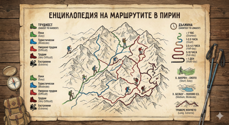
📊 Technical data (Telemetry)
- ⏱️ Duration: About 7 – 8 hours (for the entire route)
- 📏 Distance: About 12 – 13 km
- 🔥 Calories: ~1800 – 2200 kcal
- 🚶 Avg. speed: ~1.5 – 2.0 km/h (heavy rocky terrain in the alpine part)
- ⛰️ Min/Max height: ~1500 m (Demianishka Polyana mountain) / 2851 m (Polezhan peak)
- 📈 Elevation: About +610 m ascent / -1350 m descent
- 🪨 Marking: Green/Yellow to Bezbozhki Pass, Stone Pyramids (Bezbog-Polezhan-Gazey), Blue/Yellow (from Demyanitsa hut downwards)
- ⚠️ Difficulty: 5/6 (High – difficult orientation, moraines, serious descent)
💡 Interesting information
- Polezhan Peak (2851 m) is the highest granite peak in Pirin (the higher ones, Vihren, Kutelo and Banski Suhodol, are marble). Its old name is Manger Tepe (from Turkish: "covered with coins" - because of the slab stones on it).
- The Upper Gazeisko Lake, which we pass by, is the highest lake in Pirin (2642 m above sea level) and one of the highest on the Balkan Peninsula.
- Gazei Peak, although lower than Polezhan, looks extremely impressive from the Demyanitsa River valley, resembling a dark sentinel over the circus.
🚗 How to get there? (Logistics)
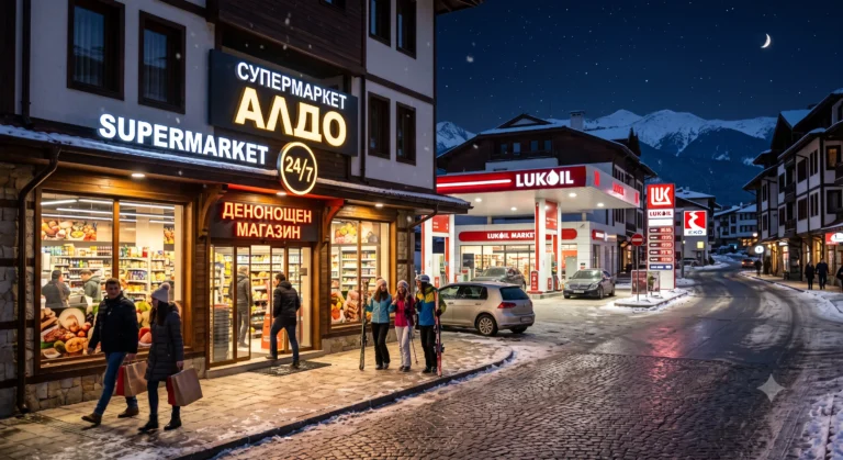
This route is linear and transfers tourists from Dobrinishte municipality to municipality Bansko,, which requires logistics.
The start is from "Bezbog" hut„. It is most easily reached by the double chairlift from the Gotse Delchev hut (above the town of Dobrinishte).
The final is on Demyanishka meadow, which is located along the Demyanitsa River valley, on the wide forest road above Bansko. From the meadow to the asphalt road to Bansko, it is about a 40-50 minute walk (to the Todorova Ornitsa area), from where you must have organized transportation (a second car or taxi) to get home.
🥾 Description of the route
1. The Storming of Polezhan Peak
From the Bezbog hut, take the steep path (green/yellow markings) to the Bezbog Pass. From the pass, you leave on a well-trodden but unmarked path (follow the stone pyramids) up the right ridge. Climbing the stone slabs of Polezhan is exhausting, but in about 2 – 2.5 hours you will reach its wide peak, from where the view is phenomenal.
2. Descent into the Gaza Circus
From Polezhan you head west to the saddle between it and Gazei Peak. From here begins a steep and wild descent into the Gazei Circus. There is practically no path - you walk along huge moraines (stone blocks), following only stone men. You reach the shores of the Upper and then Lower Gazei Lakes.
3. To the Demyanitsa hut„
After the Lower Lake, the terrain turns into steep grassy slopes and a ravine. The trail follows the valley of the Gazeiska River, which flows into the Demyanitsa River. The descent is long and tiring for the knees. In the valley, you come out onto the main trail and after a few minutes you are in front of the hospitable Demyanitsa Hut.
4. To Demyanishka Polyana
After a well-deserved rest at the hut, the easiest part remains. You take the wide, relatively flat forest road along the turbulent Demyanitsa River. After about an hour and a half of pleasant walking under the shade of centuries-old mulberries and pines, you reach the Demyanishka Polyana area (and shortly after it – the end of the hike).
🛖 Basic information about the sites (Huts)
Since the hike begins and ends at huts, you have excellent options for eating and resting at both locations.
- 📌 Tip: If you are not in a hurry, take a long lunch break at Lower Gazeysko Lake – the place is extremely wild and you will rarely meet other people.
- ☀️ Season: Optimal period: July – September. Until late summer, there are huge snowdrifts in the Gaziantep Circus!
- 💧 Water: There is no water on the way up Polezhan! Stock up at Bezbog hut. You will only find water on the way down to the Gazei Lakes.
- 📱 Orientation: The descent to the Gazean Circus requires excellent visibility. In fog, the risk of getting lost in the moraines is critical. GPS navigation is absolutely mandatory.
⚠️ Important to know
This route not marked with official color paint in its most difficult alpine section (Polezhan - Gazeyski Lakes). It relies entirely on mountaineering experience, knowledge of the terrain and stone pyramids. Traversing the huge moraines in the circus requires sturdy shoes with hard soles. In rainy weather, the slabs of Polezhan and the stones near the lakes become slippery as ice.
Winter conditions: Absolutely not recommended. The area of the Gazeian Circus and the slopes of Polezhan are avalanche traps.
❓ Frequently Asked Questions (FAQ)
Can I climb Gazei Peak (2761 m)?
Yes. When descending from Polezhan to the saddle, you can turn right along the edge towards Gazei Peak. It takes about 30-40 minutes to climb, but the peak is rocky, narrow and requires some rock climbing (beware: there are cliffs on the west side!).
Who is this route suitable for?
For advanced hikers only. The combination of serious altitude (over 2800 m), lack of a trail, walking on moraines and over 1300 meters of negative elevation (descent) makes it unsuitable for beginners and children.