vBansko is preparing for the winter season — you are viewing an early version that is updated daily. Official start December 2026

Learn more
It is 27° in Bansko now. mostly clear

Kalyata area

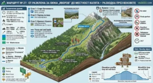
Detailed infographic map in isometric style describing the mountain Route No. 27 from the Razlog Valley to the Kalyata area in Pirin. The image includes a 3D terrain model with blue trail markings, passing through a shady mixed forest, rocky hills and the ruins of the late antique fortress Kalyata (1384 m above sea level), hanging over the Byala Reka ravine. The map is enriched with panels with technical data (Time: ~1 h, Distance: 2.5-3 km, Elevation gain: +380 m, Difficulty: 1/6 Elementary), Important warnings (lack of water, ticks, picnic areas), Logistics and a FAQ section, including the MTB route "Perfect Day" and nearby sites in Razlog and Betolovoto.

Route No. 27: From the junction for Yavorov hut to Kalyata area – a walk through the centuries