


Geography and characteristics of Vihren Peak
Basic geographical data
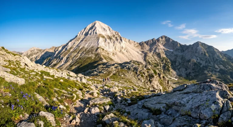
Vihren Peak Summit rises to an impressive 2914.7 meters above sea level. On a national scale, it is second only to the Rila peak Musala (2925 m), and in the Balkans it is immediately followed by the Greek Olympus (Mytikas peak – 2918 m). The peak is located on the main leveled ridge of Northern Pirin, wedged between the peaks Kutelo (2908 m) to the northwest and Hvoynati Vrh (2635 m) to the southeast. The connection with them is carried out respectively through the deep saddles Premkata (2610 m) to the north and Kabata (2535 m) to the south.
Unique geological structure and marble beauty
The most characteristic feature of the majestic Vihren peak is its composition. Its eastern and northern slopes are built almost entirely of shiny Proterozoic marbles, which give it a specific, dazzling white color. This snowy illusion is visible even in the height of summer from tens of kilometers away. These marbles reach a height of about 2600 meters, where their contact zone with the deeper limestone-silicate rocks and the granite base, dominant in the lower parts of the mountain, is located.
Due to the strongly karst nature of the marble, there are no flowing rivers or permanent lakes in the immediate vicinity of the peak – the water from precipitation and snowmelt immediately soaks into the rock cracks. A curious fact is that in the deep chute on the northern slope (in the Great Kazan circus) there is the so-called "Small Snowfield" – a microglacier measuring about 90 by 40 meters, in which the snow and ice do not melt throughout the year, resisting climate change.
Other significant peaks in Pirin Mountain
Pirin is known for its distinctly alpine relief. In addition to the absolute champion, Vihren Peak, it is home to some of the highest and most dangerous peaks in the region:
| Peak | Height (meters) | Specifics of the terrain |
|---|---|---|
| Cutelo | 2908 m | Second in Pirin, third in Bulgaria; sharp marble ridge. |
| Banski Suhodol | 2884 m | Part of the karst ridge, located next to the karst edge Koncheto Ridge. |
| Polezhan | 2851 m | The highest granite peak in Pirin, surrounded by beautiful lakes. |
| Kamenitsa | 2822 m | An emblematic sharp peak in South Pirin with technical scree. |
Popular routes to Vihren Peak
1. The Classic (Royal) Route: From Vihren Hut via Kabata
This is the most popular, relatively short and well-marked route (red marking). It is preferred by tourists with moderate physical fitness. The one-way hike takes between 2.5 and 3 hours.
- Stage 1 (To the junction for Kabata): The trail starts directly from Vihren hut (1950 m) and quickly gains altitude over rocky terrain with sparse juniper vegetation. After about an hour, you reach the Malkia Kazan area - a small grassy terrace.
- Stage 2 (Ascent to the saddle): From here the trail turns left (south) towards the Kabata saddle (2535 m). This section is steep, covered with small stones (scree), where slips are common.
- Final climb: From the Kabata saddle, the final attacking thrust begins on the southern slope of Vihren Peak itself. The elevation gain is overcome on a steep, entirely rocky marble slope with a slope of up to 45 degrees. Increased caution is required here, as the marble is heavily polished by thousands of tourists.
2. The route through Kazanite (The Wall)
A more challenging and extremely panoramic route that passes under the formidable 400-meter north face of the summit. The trail passes by the Kazana shelter (2445 m), located in the Great Kazan - a circus where you can often see wild goats and the rare edelweiss flower. From the shelter you climb steeply to the Premkata saddle, from where a technical descent or ascent along the northern edge of Vihren Peak begins. Climbing time: about 3.5 - 4 hours.
3. The extreme alpine route: From Yavorov hut through the Koncheto karst ridge
This is a real test for experienced mountaineers in excellent condition and without fear of heights (acrophobia). The route passes along the legendary cliff edge Koncheto Ridge – a place where the width of the path in places is only 50 centimeters, and sheer abysses descend on both sides. The edge is secured with a steel rope. After passing Koncheto and Kutelo Peak, the route descends to Premkata and attacks Vihren Peak from the north. The total time from Yavorov Hut is about 7 – 8 hours of intense walking.
Do you want to learn more about the sights around Bansko?
Check out our up-to-date travel guides for the Pirin region and plan your next adventure today!
Required equipment for the hike
The correct selection of personal equipment is a guarantee of your health and safety in the alpine zone of Northern Pirin:
- Shoes: Stable three-season or alpine high-mountain shoes with a hard sole are required (Vibram) and a high profile, protecting the ankle. The smooth marble rock of Vihren Peak does not forgive compromises such as sneakers or light sports shoes.
- Layering: Weather above 2500 meters changes in minutes. Use thermal underwear (merino wool or synthetics), a warm insulating layer (fleece or light down jacket) and a mandatory outer layer with a waterproof and windproof membrane (hardshell jacket).
- Sun protection: The marble rocks reflect the sun's rays like a mirror. Wear good quality sunglasses (category 3 or 4), a high factor sunscreen (SPF 50+) and a hat with a visor.
- Hydration and food: Since there are no water sources along the route, each hiker should carry at least 2.5 – 3 liters of water, preferably enriched with electrolytes. Take fast carbohydrates (energy bars, nuts, dates).
- Additional accessories: Telescopic trekking poles (reduce the load on the knees when descending by up to 25%), a headlamp (headlamp) with a full battery, mountain insurance, and a charged phone with offline GPS maps (for example, the Map.apps or Locus Map applications).
Seasonality and best time to climb
The optimal window for safe ascent Vihren peak without specialized alpine equipment is from early July to mid-September. During this period, the snowdrifts on the trails have melted, the huts are operating at full capacity, and the day is long enough.
In spring (May – June) there are still dangerous snow tongues on the chutes and at the foot of the peak, which pose a risk of slipping or giving way. Autumn (October) brings frost and rapid icing of the marble edge, which makes scrambling extremely dangerous. In winter, Vihren becomes a site of serious mountaineering – its winter ascent requires crampons, an ice axe, avalanche equipment (probe, shovel, pepper) and serious knowledge of avalanche safety.
Mountain sickness and risks on the route
Although an altitude of nearly 3,000 meters is not extreme, when climbing sharply from sea level, some hikers may experience symptoms of acute mountain sickness (AMS). These include mild headaches, rapid heartbeat, dizziness, or nausea. The best prevention is a moderate, steady pace and increased fluid intake.
The main objective dangers on the way to the summit remain sudden summer thunderstorms. The marble ridge of Pirin is highly vulnerable to lightning. If you notice rapid cumulonimbus cloud formation, immediately stop the climb and start descending to the nearest hut – Vihren or Banderitsa.
Conclusion
Conquering the highest peak of Pirin is an unforgettable experience that rewards with indescribable 360-degree panoramas of the entire Southwestern Bulgaria. Whether you choose the classic trail through Kabata, or test your adrenaline on the edge of Koncheto, Vihren Peak will captivate you with its raw, white alpine beauty. Approach the mountain with due respect, check the weather forecast, pack your backpack properly and enjoy one of the greatest mountain adventures in Bulgaria!